Welcome to the City of Puyallup’s online engagement site for the
Knutson Farms Environmental Impact Statement project. The City
is leading the development of an Environmental Impact Statement
(EIS) for a proposed warehousing development on the approximate
188-acre Knutson Farm property located outside the City limits
in unincorporated Pierce County. The EIS is an objective
analysis of the likely environmental impacts of the proposal and
measures to mitigate harmful impacts. We are committed to
listening to our stakeholders and working with you to gather
input to help inform the EIS. We’re glad you’re part of the
conversation!
Sign up for email updates.
Project Updates
UPDATE: Comments received are posted and available for review (40MB). Please note that the City is processing responses to comments as revisions occur to the EIS. Final responses to comments will occur when the FEIS is issued. If you believe your comment is missing and you submitted in a timely manner, please contact us at comment@knutsonfarmseis.org.
Project Updates
UPDATE: Comments received are posted and available for review (40MB). Please note that the City is processing responses to comments as revisions occur to the EIS. Final responses to comments will occur when the FEIS is issued. If you believe your comment is missing and you submitted in a timely manner, please contact us at comment@knutsonfarmseis.org
What's next? With the conclusion of the public comment period, the City will produce a Final EIS document and select a “Preferred Alternative”. Publication of the Final EIS is anticipated in fall of 2024.
Description of proposal and alternatives
The DEIS contains analysis of a proposed action and two
alternatives. Under the No Action Alternative, none of the
proposed facilities would be constructed.
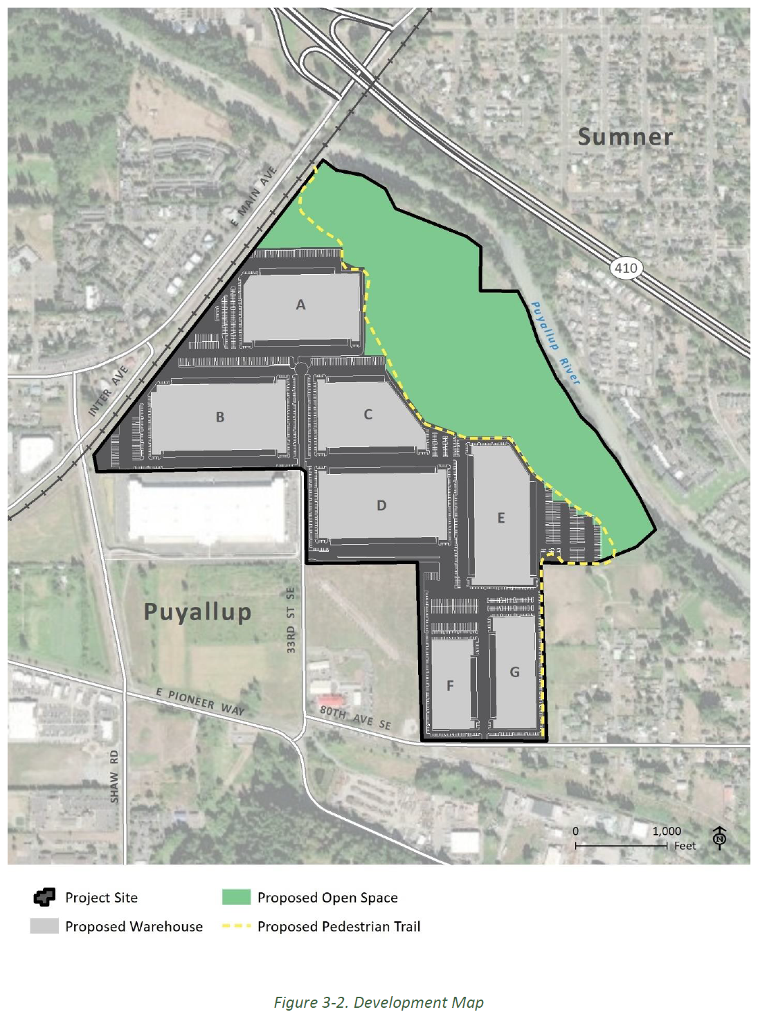
The proposed development includes construction of an
industrial park facility of up to 2.6 million square feet
of building area. The project would include construction
of seven warehouse buildings. Site work activities would
include grading, paving parking and truck maneuvering
areas, landscaping, water and sanitary sewer extensions,
building a storm water facility, franchise utility
improvements and roadway improvements.
Under Alternative 1, the facility constructed would be the
same as described for the Proposed Action; however, rail
lines would also be constructed to facilitate movement of
materials into and out of the proposed facility. The
proposed rail lines would be constructed to enable rail
access to the seven proposed warehouses from the existing
Meeker Southern rail line, which is located south of the
Project site.
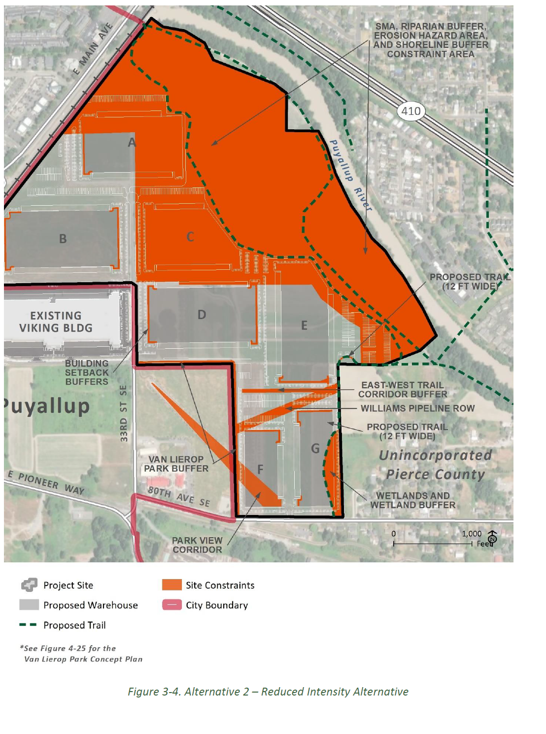
Alternative 2 considers the potential impacts that would
result if the mitigation measures that reduce the site
footprint of the facility, as outlined in this Draft EIS
for the Proposed Action, were adopted by the Applicant.
The total footprint of the Alternative 2 facilities would
be reduced from about 2.6 million square feet to about 1.7
million square feet.
The State Environmental Policy Act (SEPA) is a state law that
requires agencies to evaluate the likely environmental
consequences of proposed development actions. SEPA provides
direction for the environmental review process, including
preparation of an environmental impact statement (EIS) for
certain projects.
The City of Puyallup, as lead agency, acknowledges that there is
public interest and concern about the environmental impacts of
implementing the proposed development plan (Proposed Action).
Based on the level of concern and the potential for impacts that
may occur with the implementation of the Proposed Action, the
City has determined that a SEPA EIS will be prepared to study
impacts regardless of whether such impacts may be significant.
The project’s Determination of Significance can be found in the
Document Library.
An environmental impact statement (EIS) provides an
objective analysis of the likely environmental impacts,
feasible alternatives, and measures that would avoid or
minimize adverse environmental impacts.
An “impact” is a change in consequence that results from
an activity. Impacts can be positive, negative or both. An
EIS describes impacts and may identify ways to mitigate
them.
There are three major milestones in an EIS – Scoping,
Draft EIS, and Final EIS.
Scoping is the first step in the EIS process. During
scoping, we invited agencies, tribes, and the general public
to comment on the likely range of project alternatives and
areas of impact that should be evaluated. These comments
were used to narrow the focus of the EIS to the likely
significant environmental issues, eliminate insignificant
impacts from study, and identify alternatives for analysis
in the EIS.
The project team has analyzed the following environmental
elements within the DEIS. For each environmental element, we
have evaluated the probable impacts associated with the
proposed action and operations:
Transportation, particularly transportation systems and
traffic
Public services and utilities, including stormwater,
sanitary sewer and fire flow and fire protection services
Water, plants and animals
Cultural resources
Noise
Air quality, including greenhouse gases
Land and Shoreline use, including aesthetics, recreation,
agricultural crops, and the project’s relationship to
existing land use plans
Alternatives
Mitigation measures
The project team examined potential impacts and broke them
into two categories: Construction and Operations impacts.
Construction impacts would occur during the ongoing
construction of the project, while operations impacts would
continue throughout the lifespan and active use of the
project site.
DEIS definition of impact significance: SEPA requires that
an EIS analyze the adverse environmental impacts of a
proposal and identify possible mitigation measures that will
reduce or eliminate those impacts. For each environmental
resource area, the following thresholds were considered for
impacts:
Significant Impact: the impact is irrevocable;
there are no regulatory requirements, design measures,
and/or mitigation measures that would avoid, minimize, or
reduce the potential impacts identified.
Mitigated Significant Impact: the potential impact
identified is substantial and adverse; however, impacts
could be avoided, minimized, or reduced with
implementation of regulatory requirements, design
measures, and/or mitigation measures.
Less than Significant: the potential impact is
neither substantial nor adverse; no mitigation is
required. However, Best Management Practices (BMPs) would
be implemented to reduce impacts as appropriate.
No Impact: there are no identified impacts to the
resource area.
A full list of DEIS chapters, as well as previous
documentation, can be found in the
Document Library.
Following the DEIS comment period, the City of Puyallup will
prepare a Final EIS, including a response to comments
received.
Knutson Farms EIS schedule
Fall 2020
Issue Second Request for Further Comments on Scope of
EIS
EIS scoping
2021 through Fall 2023
Conduct fieldwork and impacts analyses
Prepare Draft EIS
Fall 2023/Winter 2024
Issue Draft EIS
Draft EIS public comment period
Summer 2024
Prepare Final EIS
Issue Final EIS
Draft Environmental Impact Statement
The Draft Environmental Impact Statement describes the findings
of environmental analysis across a comprehensive set of topics.
Explore the sections below to learn more about key topics of
community interest and related DEIS chapters. A full list of
DEIS chapters, as well as previous documentation can be found in
the Document Library.
Section 4.9 of the DEIS looks at transportation. See
below for highlights from the DEIS, key mitigation
measures, as well as to link to a comprehensive summary
of the impacts analysis and proposed mitigation measures
associated with these actions.
‘Build scenarios’ studied in the traffic impact analysis
report:
The six scenarios shown in Table 4-32 were considered
and analyzed for the expected project completion and
operation year 2026.
Table 4-32. Build Scenarios Analyzed
Build Scenario
Total SF
Total Daily Trips
Total PM Peak Hour Trips
Total Heavy Vehicle Trips
A – Proposed Action
2.6M SF
8,724 vpd
880 vph
1,482 vpd
B – Rail scenario (Alternative 1)
2.6M SF
8,487 vpd
729 vph
1,207 vpd
C – Proposed Action, with mitigation
2.6M SF
8,724 vpd
880 vph
1,482 vpd
D – Reduced land use scenario (Alternative 2)
1.73M SF
5,844 vpd
590 vph
998 vpd
E – Reduced land use scenario (Alternative 2), with
mitigation
1.73M SF
5,844 vpd
590 vph
998 vpd
Note: M = million, SF = square feet, vpd = vehicles per
day, vph = vehicles per hour
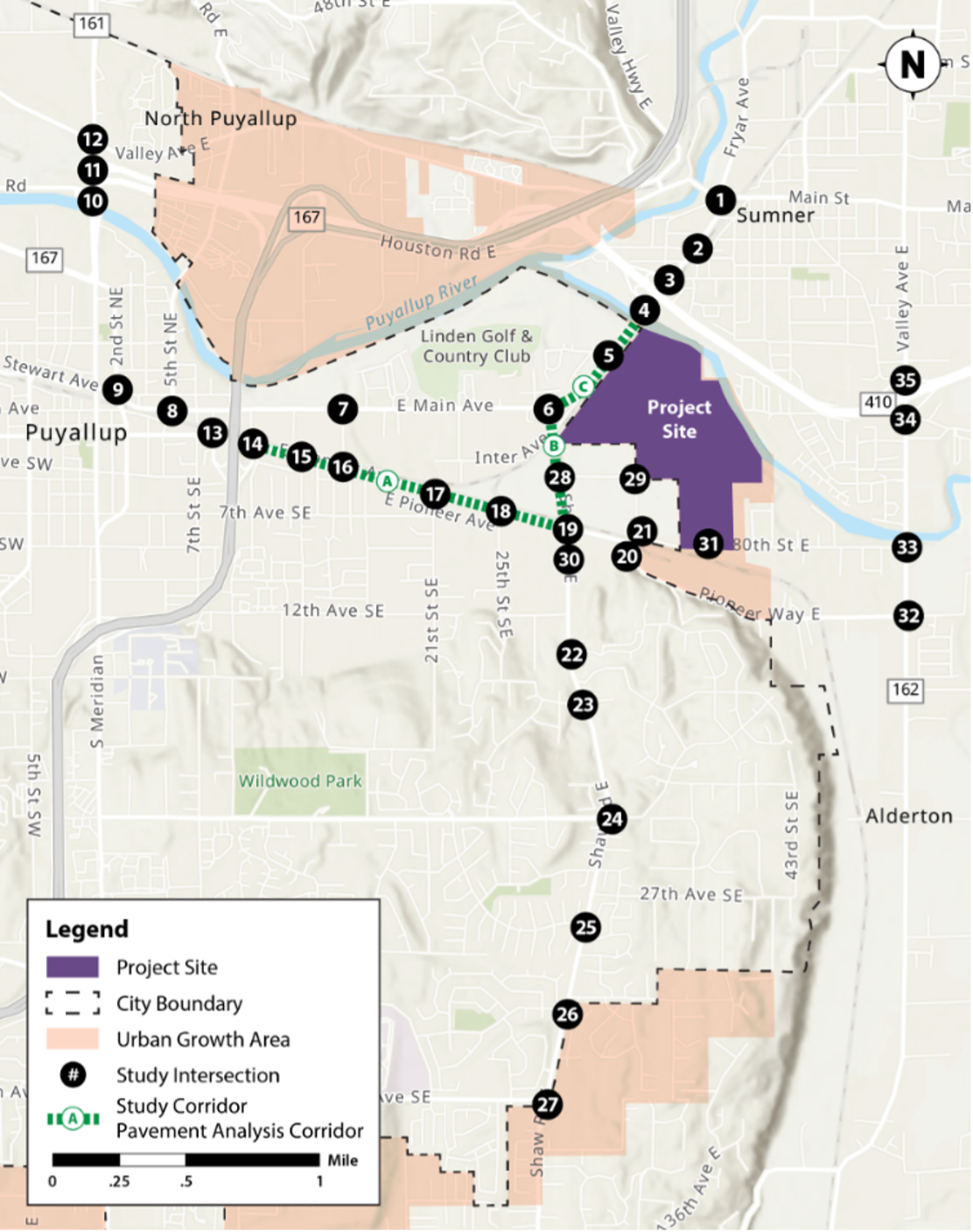
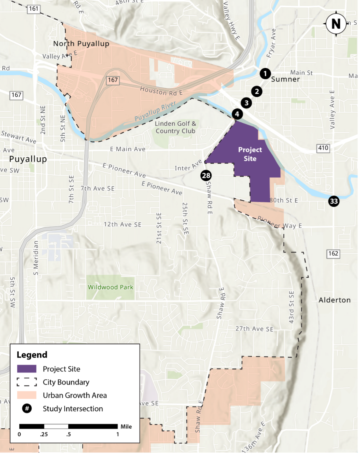
Intersections and corridors studied in the traffic
impact analysis report:
Thirty-five counted intersections and three safety study
corridors were studied in in the DEIS, shown below in
Figure 4-60.
Scenario C (proposed action) – Traffic Impact
Mitigation Applied
Intersection Location
Mitigation Applied
Traffic Ave/Fryar Ave & Main St/Cannery Wy
Retime and coordinate signal
Traffic Ave & State St
Retime and coordinate signal; this intersection
requires retiming even though it meets LOS
thresholds due to proximity to SR 410
E Main Ave & SR 410 WB
Retime and coordinate signal length, eliminate split
phase signal operations by restriping intersection
and allowing eastbound and westbound left turns to
run concurrently
E Main Ave & SR 410 EB
Retime and coordinate signal
N Meridian Ave & Valley Ave NE
No mitigation applied
E Pioneer & 25th St SE
Unsignalized – no mitigation applied
E Pioneer & Shaw Rd E
Retime and coordinate signal
Shaw Rd E & Highlands Blvd
Unsignalized – no mitigation applied
Shaw Rd E & 5th Ave SE
Widen 5th Avenue and convert unsignalized
intersection to a signal with dedicated westbound
left and right turn lanes. Widen 5th Avenue to a
3-lane roadway section; widen 5th Ave to a
three-lane roadway section; retime and coordinate
signal
SR 162 & 80th St
Convert to roundabout
Scenario E (Alternative 2) – Traffic Impact
Mitigation Applied
Intersection Location
Mitigation Applied
Traffic Ave/Fryar Ave & Main St/Cannery Wy
Retime and coordinate signal
Traffic Ave & State St
Retime and coordinate signal; this intersection
requires retiming even though it meets LOS
thresholds due to proximity to SR 410
E Main Ave & SR 410 WB
Retime and coordinate signal length, eliminate split
phase signal operations by restriping intersection
and allowing eastbound and westbound left turns to
run concurrently
E Main Ave & SR 410 EB
Retime and coordinate signal
Shaw Rd E & 5th Ave SE
Widen 5th Avenue and convert unsignalized
intersection to a signal with dedicated westbound
left- and right-turn lanes with dedicated westbound
left- and right-turn lanes; widen 5th Ave to a
three-lane roadway section; retime and coordinate
signal
SR 162 & 80th St E
Convert to roundabout
Other mitigation:
Additional mitigation to offset impacts to roads include
ADA accessibility, transit stop improvements,
proportional fees for impacts to
volume-to-capacity/congestion to local major corridors
and pavement impacts will apply to the project. See
section 7 of the traffic impact analysis
and
Appendix E - traffic report.
Summary of environmental analysis and mitigation
Table 1-1 summarizes the potential environmental impacts
associated with the No Action Alternative, Proposed
Action, Alternative 1, and Alternative 2 as well as the
potential mitigation for the identified impacts.
Click here
to see the summary for Section 4.9 – Transportation.
Section 4.5 of the DEIS looks at land and shoreline use.
See below for highlights from the DEIS, key mitigation
measures, as well as to link to a comprehensive summary
of the impacts analysis and proposed mitigation measures
associated with these actions.
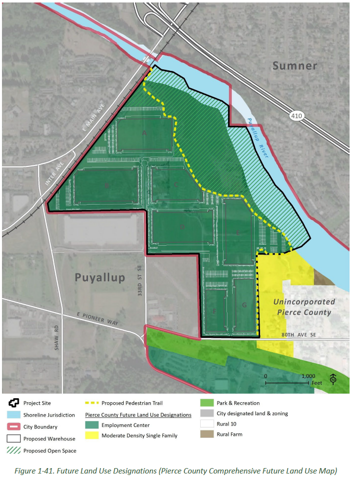
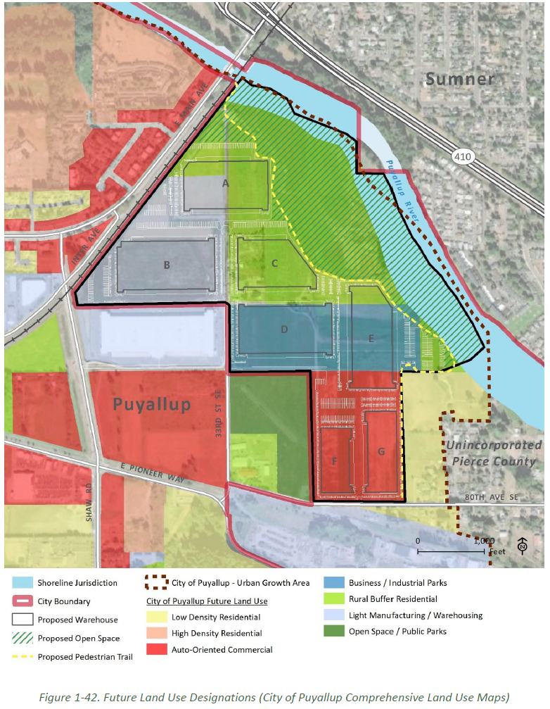
Future land use designations:
Analysis in the DEIS includes consideration of future
land use designations identified in both the Pierce
County Comprehensive Plan and City of Puyallup
Comprehensive Plan, as shown in Figures 1-41 and 1-42,
below. The land use analysis evaluates the Project’s
potential to result in land use conflicts and/or plan
and policy inconsistencies that would consequently be
considered land use impacts.
Key mitigation measures:
LU-1: Development limits on city Comprehensive Plan
designation areas.
During building permit review and prior to design
approval, the Applicant should provide a revised site
plan that limits development to areas designated as
Auto-Oriented Commercial, B/IP, and LM/W as shown on
the City’s Comprehensive Plan future land use map
only; any future development permit applications would
not construct or develop on lands designated RBR in
the city Comprehensive Plan. This could result in
Building C being removed and Buildings A and E being
shifted, relocated, redesigned, and/or reduced in
size. Eliminating development from areas designated
RBR on the CPCP map would be consistent with the
City's FLUM, which was developed in cooperation with
the County policy priorites to preserve agricultural
land.
LU-4 Conservation Easement. LU-4 Conservation
Easement: The applicant should voluntarily place a conservation
easement on areas of the Project site that are
currently identified as planned for open space uses.
This would be consistent with the Pierce County
Alderton-McMillin Community Plan’s desired conditions
to “maintain the rural character of the community into
the future” (A-25) and with the City of Puyallup
Comprehensive Plan Policy LU-9.2, which calls for
using conservation incentives for preservation of
agricultural lands as part of an urban growth strategy
and the Project site being located within a mapped
Open Space Corridor network (Pierce County
Comprehensive Plan Goal LU-115, Goal LU-119, Goal
PR-21 and Policy PR-21.3).
Summary of environmental analysis and mitigation
Table 1-1 summarizes the potential environmental impacts
associated with the No Action Alternative, Proposed
Action, Alternative 1, and Alternative 2 as well as the
potential mitigation for the identified impacts.
Click here
to see the summary for Section 4.5 – Land and Shoreline
Use.
Section 4.13 of the DEIS looks at noise. See below for
highlights from the DEIS, as well as to link to a
comprehensive summary of the impacts analysis and
proposed mitigation measures associated with these
actions.
Analysis in the DEIS considers the maximum permissible
environmental noise levels (dBA) at receiving locations,
as presented in Table 1-69. Under WAC 173-60-050 (4)(l),
sounds created by motor vehicles are subject to the
maximum permissible environmental noise levels when
those sounds are received in EDNA Class A Environments
(i.e., parks or residential areas).
Table 1-69. Distance from Operating Vehicles Maximum
Allowable Noise Levels
Source: HDR 2022
Nighttime
Daytime
Maximum Allowable Noise Limit (dBA)
50
55
60
65
60
65
70
75
Allowed Exposure per hour
N/A
15 min
5 min
15 min
N/A
15 min
5 min
1.5 min
Passenger/Light Duty Vehicles
N/A
50 ft
25 ft
N/A
25 ft
25 ft
25 ft
25 ft
Heavy Duty Vehicles
2,000 ft
950 ft
450 ft
200 ft
450 ft
450 ft
100 ft
50 ft
Key mitigation measures:
N-2. Prioritize Construction of Noise Restricting
Project Elements. In accordance with the community character elements
of the Puyallup Comprehensive Plan (CC-2.3, CC-6.6,
CC-11, and CC-11.1), the Applicant shall construct all
required perimeter landscaping and berming, install
required fencing, and plant required landscaping prior
to beginning site work and building construction on
site for all areas abutting Van Lierop park and where
residential land uses are adjacent to or abutting the
Project Site. Additionally, consider a grading plan
that would store and stockpile earth in manner and
location that would deflect and attenuate noise from
the Project Site away from residential and public
parkland uses throughout all phases of construction.
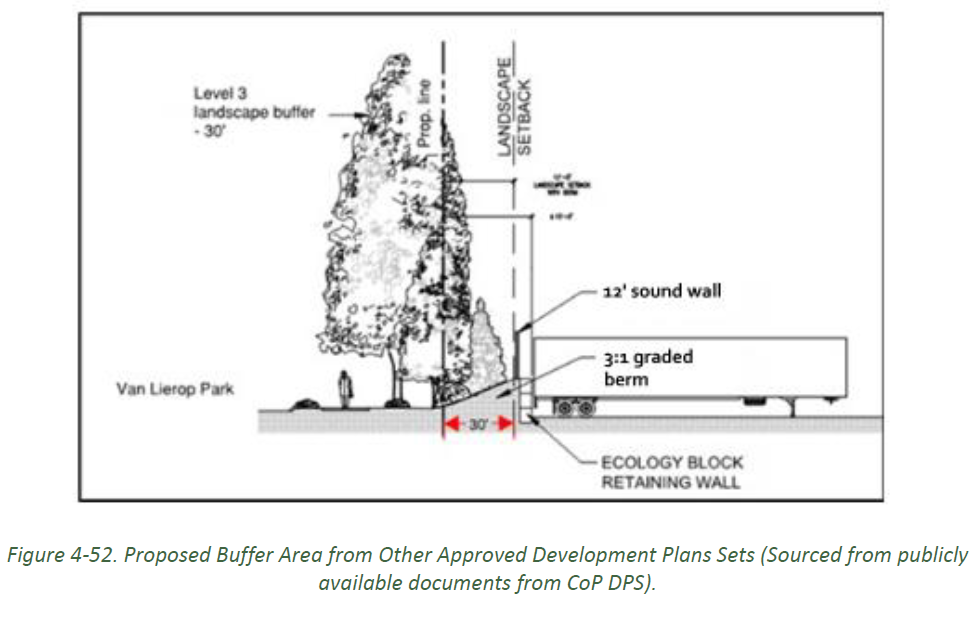
N-3: Construct Noise Walls. Noise
walls would be required to mitigate noise generated
from vehicle traffic on site. Twelve-foot-high noise
walls would be required along all shared property
boundaries with Van Lierop Park and along the Project
boundary to the east of Warehouses E and G between the
Project and the adjacent residential zones. The
12-foot-high wall was the shortest wall that would
lower noise levels to below the maximum permissible
noise levels as outlined in WAC 173-60-040 (HDR 2022).
Summary of environmental analysis and mitigation
Table 1-1 summarizes the potential environmental impacts
associated with the No Action Alternative, Proposed
Action, Alternative 1, and Alternative 2 as well as the
potential mitigation for the identified impacts.
Click here
to see the summary for Section 4.13 – Noise.
Section 4.2 of the DEIS looks at surface water. See
below for highlights from the DEIS, as well as to link
to a comprehensive summary of the impacts analysis and
proposed mitigation measures associated with these
actions.
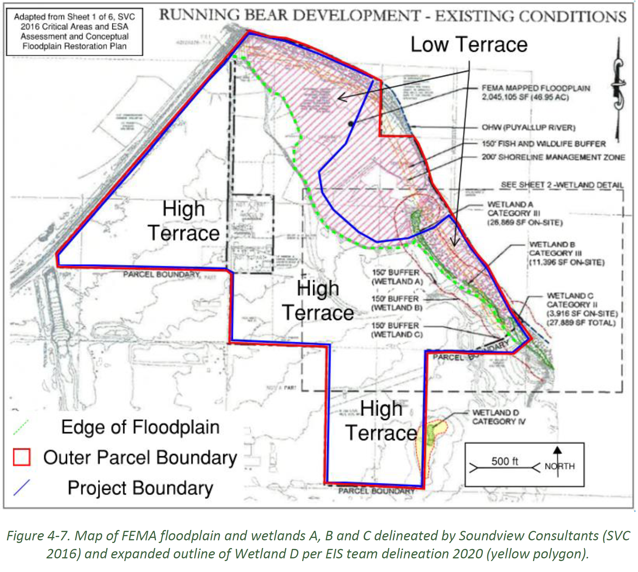
Surface waters considered in this analysis include the
Puyallup River and its floodplain, onsite wetlands in
the floodplain to the east (Wetlands A, B, C) and
Wetland D, a depressional wetland located on the high
terrace in the southeast KFIP project site.
Key mitigation measures:
SW-1 Evaluate the outfall erosion issues
prior to Hearing Examiner hearing and prior to County
and Hearing Examiner approval and final KFIP
permitting and take corrective action as needed to
redesign, repair, or relocate the stormwater outfall
structure or components of the Project-wide stormwater
management plan in relation to future flow increases
from the KFIP Project site.
SW-4 Surface and Groundwater Hydrology
monitoring
prior to final site design and construction in all
on-site wetlands to define hydroperiods13, as needed
to develop effective plans to preserve current wetland
hydrology, as required in Code.
SW-6 Wetland D impact avoidance.
Avoiding impacts to Wetland D would prevent
significant harm to this resource. The permitting
agencies should review if the project has followed
proper mitigation sequencing and if the objectives can
be met without filling Wetland D.
For more detail, see page 4-107 of the DEIS.
If the Project were revised to avoid all impacts
to Wetland D and its regulated buffer, no
significant impacts would occur to this resource
on site.
The permitting agencies (Pierce County, and
Ecology) should determine how the Applicant has
properly followed standard mitigation sequencing,
including initial avoidance of the impact
altogether and site planning design changes needed
to avoid or minimize loss of wetland and buffer
area at Wetland D.
The permitting agencies should document if an
alternate site plan that does not fill Wetland
Dstill allows for reasonable economic use and if
the Project objective can still be fulfilled
without fill of and construction over Wetland D of
the KFIP site.
If the mitigation sequencing were to be fulfilled,
the Applicant is expected to prepare a mitigation
plan and file a JARPA form with Ecology and Pierce
County to initiate regulatory review of the
current KFIP proposal, which is to fill a portion
of Wetland D and its associated onsite buffer.
If fill of Wetland D and its buffer is permitted
by all of the agencies listed above, a final
detailedmitigation plan addressing Wetland D fill
should be completed and implemented prior to
construction, following standard mitigation and
minimization sequencing protocols.
SW-7 Mitigation and monitoring plan.
Depending on the outcomes of SW-6, per PCC 18E and
Ecology requirements, a JARPA permit process would
require a detailed mitigation and monitoring plan to
be developed as conditioned during the review
described above.
For more detail, see page 4-108 of the DEIS.
Summary of environmental analysis and mitigation
Table 1-1 summarizes the potential environmental impacts
associated with the No Action Alternative, Proposed
Action, Alternative 1, and Alternative 2 as well as the
potential mitigation for the identified impacts.
Click here
to see the summary for Section 4.2 – Surface Water.
Topic highlights: Effects to Aesthetics
Section 4.6 of the DEIS looks at aesthetics. See below
for highlights from the DEIS, as well as to link to a
comprehensive summary of the impacts analysis and
proposed mitigation measures associated with these
actions.
This section describes the potential for environmental
impacts related to aesthetics as a result of Project
implementation. Aesthetic experiences can be highly
subjective; therefore, Project-related impacts are
evaluated based on the extent of the modifications to
existing physical conditions on the Project site as a
result of the Project. Given the Project’s context and
placement within an existing rural developed setting,
this analysis follows a qualitative approach to assess
the potential visual impacts related to the Project.
This analysis was performed by defining the Project
location and setting; identifying and characterizing the
existing visual resources and key viewers; and assessing
resource change and viewer response.
Key mitigation measures:
AES-2: Comply with Screening, Landscape and
Buffering Requirements.
The Applicant should use landscaping buffering to
promote compatibility between land uses and to reduce
the visual impacts of development on users of the site
and abutting uses, including the proposed trail. The
Project should comply with local building code
regulations, including Title 18J.10.055(6) PCC, which
requires landscape plans that include the locations
and types of landscape buffers and maintenance
measures. The landscape buffering should also comply
with Title 18J.15.040 PCC, a Level 3 Landscape Buffers
requirement, and provide a substantial mix of
evergreen and other landscaping elements, including
berms and sound walls that buffer the visual and
auditory impacts.
For more detail on this mitigation, see the full
text.
Summary of environmental analysis and mitigation
Table 1-1 summarizes the potential environmental impacts
associated with the No Action Alternative, Proposed
Action, Alternative 1, and Alternative 2 as well as the
potential mitigation for the identified impacts.
Click here
to see the summary for Section 4.6 – Aesthetics.
Section 4.7 of the DEIS looks at recreation. See below
for highlights from the DEIS, as well as to link to a
comprehensive summary of the impacts analysis and
proposed mitigation measures associated with these
actions.
The recreation analysis is based on consistency with
plans and policies and includes general compatibility
considerations by evaluating the Project’s potential to
result in temporary or permanent loss of use of a
recreation use/facility or a substantive change in
overall user enjoyment or recreational experience.
REC-1: Eliminate Van Lierop Park Prime View
Corridor Obstructions.
During building permit review and prior to design
approval, the Applicant should modify the proposed
site plan to remove proposed structures from the view
corridor and place a restriction on the title that
prohibits blocking or in any way obscure, produce
glare, or visually impact the view corridor created in
Van Lierop Park as shown in Key Observation Point
(KOP) 5. The Applicant should show (using visually
aided representations of the vertical massing and
height of buildings using architectural modeling
software) that changes to the site plan have been
fully made to avoid and mitigate impacts on the
natural environment, the built environment, and the
visual quality of these environments and the intent of
Van Lierop Park Mount Rainier prime view
corridor.Building F, as well as potentially portions
of Building G (pending final visual analysis), would
need to be eliminated, shifted, relocated, redesigned,
and/or reduced in size to not create impacts.
Additionally, no parking lot(s) or landscaping of
trees should occur in the view corridor as those
improvements would also create visual interference,
glare, screening, and other visual blockage of the
public view corridor of Mount Rainier from Van Lierop
Park. The park view corridor area should remain as
open space to prevent visual obstruction from a major
community park. The Applicant and permitting agency
(Pierce County) should consult with and receive
concurrence from the city of Puyallup Development and
Permitting Services and Parks Departments on the
visual assessment during permit review by Pierce
County. This mitigation measure is consistent with
Pierce County Comprehensive Plan Policy LU-47.8 and
Pierce County Comprehensive Plan and PROS Plan
Policies PR 1.3 and PR 5.6, as well as City of
Puyallup Comprehensive Plan Policy CC-1.3, Policy
CC-2.2, and Goal CC-3.
REC-4: Modify the Site Plan to Provide a New Trail
Location.
The Applicant should modify the site plan to provide a
new multipurpose trail location, one that runs along
the southern bank of the Puyallup River consistent
with the location identified in the 2020 Puyallup PROS
Plan, as an extension of the existing
Foothills/Riverwalk Trail, in keeping with the
intended user experience of the Riverwalk Trail to
provide the public with a visual connection and/or
shoreline access to the Puyallup River. This should
include conducting a Trail Routing Feasibility
Analysis. The Trail Routing Feasibility Analysis
should determine where the least impactful location
would be to relocate the proposed trail along the
shoreline of the Puyallup River; the Applicant should
identify a trail route that will be in conformance
with the County and City SMPs and PROS Plans, as well
as minimize impacts on floodplain, CMZ(s) and critical
areas, and mitigate for any impacts. Special
designs—such as elevated boardwalks—should be
considered to bridge wetlands, and maintain flood
storage capacity and sensitive areas and buffers.
Pierce County Parks, City of Puyallup Parks, and user
advocate groups (Foothills Trail coalition, Friends of
the Riverwalk Trail) should review the overall
dimensions and cross section of the trail corridor.
The trail design throughout the site planning should
utilize significant landscape buffering to separate
physically and visually the trail from the industrial
park to protect the trail user experience from impacts
from the Project operations while implementing Crime
Prevention Through Environmental Design (CPTED)
principles and incorporating visual public access to
the shoreline environment.
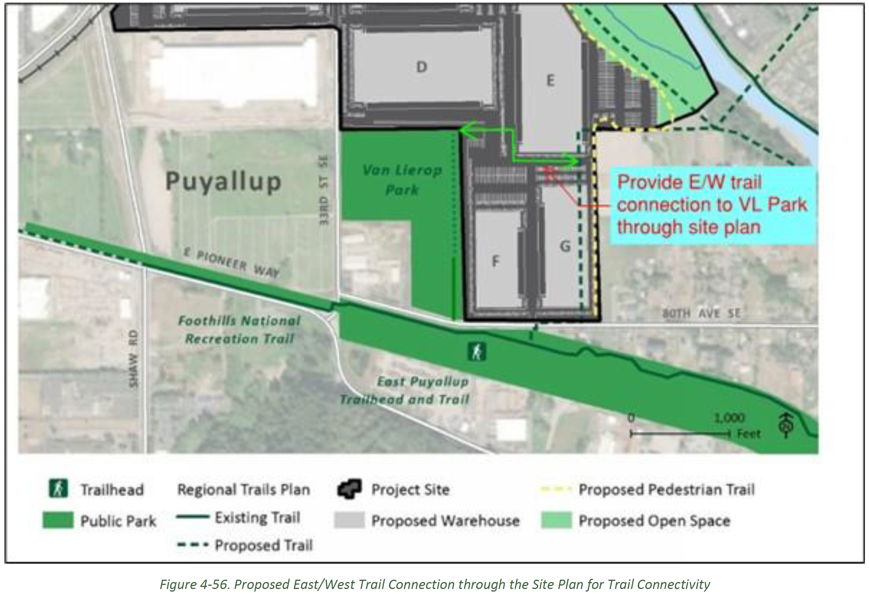
REC-5: Provide a Trail Connection to Van Lierop
Park.
Consistent with County and City policies calling for
trail connectivity with other recreation facilities
and community activity centers, the Applicant should
provide a trail connection to Van Lierop Park (Pierce
County Comprehensive Plan Policies PR-10 and PR-17.1,
City PROS Plan Policy 2.3). This could be an east/west
trail connection through the site plan to allow trail
connectivity from the northwest corner of the park to
the trail corridor as shown on the proposed site plan,
though it is possible a different alignment may be
preferred, for instance, if the site plan changes as
called for in other mitigation measures in this EIS.
One concept could be to modify the portion of the site
containing Buildings F and G by creating a trail
corridor break in the site plan to separate the
complex into two separate sites with no vehicular
access between them. This would create a protected
corridor to allow for an east-west connection from Van
Lierop Park to the proposed trail on the Project site.
The trail corridor could also potentially be placed in
the Williams Pipeline corridor, pending approval from
Williams through an encroachment agreement. Any
connection through the site should contain appropriate
landscape buffering, raised crossings,
limited/consolidated driveway/parking lot crossings of
the trail, and other features to protect trail users,
such as way-finding signage indicating “public trail
connection” that allow for safe access to the trail.
The Project Applicant and Pierce County should seek
input from the City of Puyallup Parks Department and
Development and Permitting Services Department as the
site plan is revised to meet this mitigation measure.
Summary of environmental analysis and mitigation:
Table 1-1 summarizes the potential environmental impacts
associated with the No Action Alternative, Proposed
Action, Alternative 1, and Alternative 2 as well as the
potential mitigation for the identified impacts.
Click here
to see the summary for Section 4.7 – Recreation.
We want to hear from you!
The DEIS comment period was open December 14, 2023 - March 15,2024
UPDATE: Comments received are posted and available for review (40MB). Please note that the City is processing responses to comments as revisions occur to the EIS. Final responses to comments will occur when the FEIS is issued. If you believe your comment is missing and you submitted in a timely manner, please contact us at comment@knutsonfarmseis.org.
What's next? With the conclusion of the public comment period, the City will produce a Final EIS document and select a “Preferred Alternative”. Publication of the Final EIS is anticipated in fall of 2024.
The City of Puyallup released the EIS scoping report comment
summary related and all comments received during the scoping
comment period, available here:
To learn more and access publicly available materials, visit
Pierce County PALS Online
and search permit ID numbers 792206 and 792210.
Draft Environmental Impact Statement
Below, you will find a list of all chapters within the DEIS,
as well as a table (Table 1-1) summarizing proposed
mitigations for each topic. Within these chapters you can find
detailed information on the study area, methodology, findings
and mitigations for each topic under each Alternative.
** Note that if you are using Adobe browser
extensions/plugins, Bluebeam, etc., links to specific
sections of the DEIS may not operate and you will need to
navigate manually.
The City of Puyallup (City) hired a team of environmental
consultants to conduct a rigorous and independent review of
the project in an environmental impact statement (EIS)
prepared pursuant to the State Environmental Policy Act
(SEPA). The Draft EIS is now ready for review, and the
public has the opportunity to provide comments on the
findings from December 14, 2023 to March 15, 2023. The City
will review all comments received and prepare a Final EIS,
expected in summer 2024.
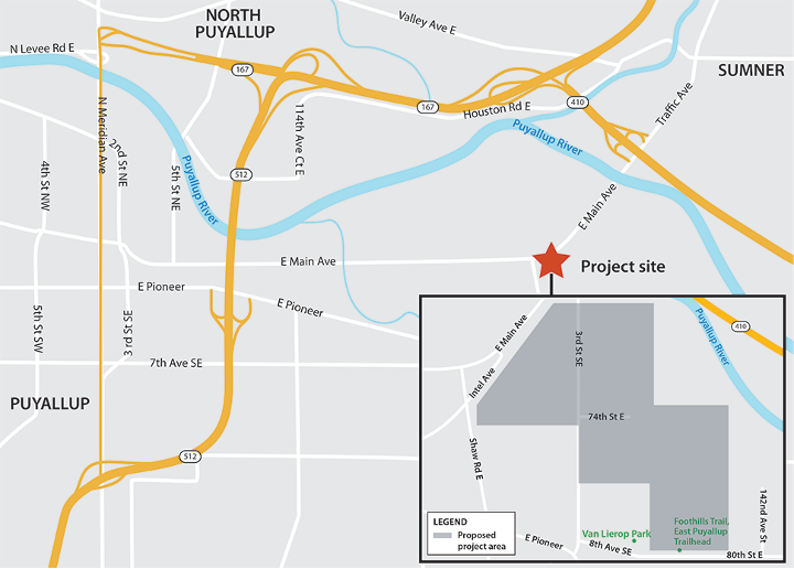
The 188-acre property is located in Pierce County, just
outside of Puyallup’s corporate limits. However, the project
area is within the City’s Urban Growth Area (UGA). According
to the Washington State Growth Management Act and the City’s
Comprehensive Plan, property located within a jurisdiction’s
UGA is anticipated to someday be annexed into that
jurisdiction.
The original development proposal was submitted to Pierce
County by the landowner in 2014. The seven-building
warehouse project raised several questions and concerns for
the City of Puyallup about traffic impacts, utility needs,
floodplain and wetlands management, and impacts to nearby
parks among other areas of the natural and built
environment. The City proposed in June 2016 that Pierce
County and the City jointly prepare a full EIS, but this
proposal was rejected. Given the number of unaddressed
concerns about the proposal and location within the City’s
UGA, the City therefore pursued legal challenges to the
County’s environmental review. After Pierce County Hearing
Examiner and court proceedings, in 2019 the Washington Court
of Appeals issued a decision upholding the City of
Puyallup’s right to act as the lead SEPA agency for the
project and to require preparation of an EIS on it. The
Washington Supreme Court subsequently dismissed Pierce
County’s petition that the Court review (and potentially
overturn) the Court of Appeals decision.
The Knutson Farms EIS project is currently focused receiving
public comment following the issuance of the Draft EIS.
An EIS is prepared when the lead SEPA agency determines a
proposal is likely to have significant adverse environmental
impacts. The EIS process is a tool for identifying and
analyzing:
Probable adverse environmental impacts
Reasonable alternatives
Possible mitigation strategies
The Final EIS (FEIS) will include objective ways that
environmental impacts can be avoided or minimized and
provides a basis for decision making about the project
application. Once a decision is made to pursue a preferred
alternative in the FEIS, the mitigation required to minimize
environmental impacts should be integrated into the final
design.
The Draft EIS looks at several alternatives, or options, for
a proposed development. The DEIS will consider the following
different scenarios:
Do not build the proposed development (No Action)
Build the proposed development as planned (the Proposed
Action)
Consider other build alternatives, including
Alternative 1, which integrates a rail line into the
proposed project, or
Alternative 2, which reduces the site footprint of the
facility
The project team reviewed all comments submitted during the
EIS scoping comment period (November 17, 2020 through
December 17, 2020). The City of Puyallup released an
EIS scoping summary report, which summarized the comments received. Further, all
comments received during the scoping comment period are
now available on this website. Your comments helped determine the environmental factors
to study. In some instances, factors that were not already
planned for analysis were added to the scope based on your
comments.
Scoping, the first step in developing the EIS, defines
which environmental factors to study and the extent of
analysis for each factor. As noted above, the scoping
public comment period helped informed which factors to
include in this EIS. The environmental factors for the EIS
analysis include:
Transportation, particularly transportation systems and
traffic.
Public services and utilities, including stormwater,
sanitary sewer and fire flow, and fire protection
services.
Water, plants, and animals.
Cultural resources.
Noise.
Air quality, including greenhouse gases.
Land and shoreline use, including aesthetics,
recreation, agricultural crops, and the project’s
relationship to existing land use plans.
Alternatives.
Mitigation measures.
SEPA also requires consideration of the cumulative impacts
(WAC 197-11-060) of a proposal. Cumulative impacts are
those impacts that occur when considered with the impacts
from other past, present, or future actions or projects.
The Draft EIS was released on December 14, 2023. The 90-day
public comment period opened upon its issuance, ending March
15, 2024 . Following review of the public comments, a Final
EIS document is anticipated to be released in summer 2024.
The Draft EIS is an opportunity to comment on the
alternatives being studied and comment on the
environmental impact analysis of the project. We will ask
tribes, agencies, and the public for the following
comments on the Draft EIS, including the following:
Comments or questions on the technical analysis in the
Draft EIS.
Comments that help us select a preferred alternative.
Comments related to the environmental topics that were
studied.
Note, all comments received become part of public record
and may be publicly displayed, including your name. Other
personal details will not be published.
The City of Puyallup will consider all feedback from tribes,
agencies, and the public before drafting the Final EIS. We
will respond to timely comments in the Final EIS.
Substantive comments are comments that help us refine the
EIS analysis or select a preferred alternative.
The City, acting as Lead Agency, defined and studied
reasonable alternatives in the DEIS and may identify (at the
FEIS stage) a ‘Preferred Alternative’ that could feasibly
attain or approximate a proposal's objectives, but at a
lower environmental cost or decreased level of environmental
degradation. The City anticipates making that final
determination after considering all public and agency
comments and input.
Pierce County has approval authority over many aspects of
the overall project. The City has jurisdiction over certain
discrete aspects of the proposal, such as specific roadway
mitigation requirements and some utility connections (water,
sewer). To ensure that significant impacts are mitigated,
such permitting agencies when issuing final permits, should
adhere to the mitigation recommendations made in the final
EIS.
The Applicant and the City of Puyallup recorded a
Declaration of Restrictive Covenant in August 2022 that
establishes a stated intent to develop the Project as an
“Industrial Park” consistent with the Institute for Traffic
Engineers (ITE) Land Use Code (LUC) 130 (ITE manual, 11th
edition). According to ITE LUC 130, “(a)n industrial park
contains several individual industrial or related
facilities. It is characterized by a mix of manufacturing,
service, and warehouse facilities with a wide variation in
the proportion of each type of use from one location to
another.” As of the preparation of this document, the
Applicant has yet to make a binding commitment on the final
end user(s) of the proposed facilities. The restrictive
covenant does establish that no “high cube fulfillment
center” uses will be occupying the structures on site.
.png)